
GLÖZ II backdrop
Which datasets matter when screening sites for peatland PV? This article explains GLÖZ II (GAEC 2) reference layers, other peatland maps and technical potential, and shows how harmonised nationwide data supports early-stage site assessment.
GLÖZ II (GAEC 2) Layers and Peatland PV: Which Data Matters for Site Screening
Updated in July 2026
Under the German Renewable Energy Sources Act (Erneuerbare-Energien-Gesetz, EEG), solar parks on drained peatland are generally excluded from support under the EEG. Certain special solar installations may qualify, however, if the peatland was previously drained and used for agriculture and is permanently rewetted in connection with the construction of the installation (see section 37(1) no. 2 and section 37(1) no. 3(e) EEG).
134 to 268 gigawatts peak (GWp): This is the Fraunhofer Institute for Solar Energy Systems ISE’s estimate of the technical potential for peatland PV in Germany.
The scale of this estimate illustrates the role peatland PV could play in the future. For project development, however, it does not answer the crucial question: Which sites qualify as peat soil, and which dataset is relevant for assessing them?
What is peatland PV?
Peatland PV refers to photovoltaic installations built on previously drained peat soils where the land is permanently rewetted in connection with the solar project.
The approach is intended to combine two objectives: generating renewable energy and restoring the climate mitigation function of peatlands. Drained peat soils release significant amounts of greenhouse gases. Raising the water table can reduce these emissions.
The Fraunhofer ISE guidance document summarises the current state of knowledge on planning, technology, permitting and implementation. At the same time, it makes clear that practical experience with peatland PV remains limited. Further research is needed, particularly on long-term technical implementation, rewetting and potential combinations with paludiculture.
Peatland PV under the EEG
Under the current section 37 EEG, solar installations on drained peat soils previously used for agriculture may qualify as special solar installations and receive support under certain conditions. A central requirement is the permanent rewetting of the site in connection with the construction of the installation.
Whether a specific project meets these conditions does not depend on its location on peat soil alone. The applicable requirements of the German Federal Network Agency, the technical feasibility of rewetting and other planning and permitting requirements must also be assessed.
Not every peatland map serves the same purpose
Germany has a range of datasets covering peat soils and carbon-rich soils. These include:
- nationwide soil maps and research datasets;
- the Thünen Institute’s organic soils dataset;
- the Aggregated Map of Organic Soils in Germany compiled by the Greifswald Mire Centre;
- soil maps and thematic information published by the federal states; and
- data from the respective state geoportals.
These datasets differ in purpose, spatial resolution, date of collection and classification. A site may therefore be included in a scientific peatland map without this automatically resulting in a particular legal classification.
For project development, the relevant question is not only whether a dataset shows peat soils, but also the purpose for which the dataset was created.
What is the GLÖZ II (GAEC 2) reference layer?
GLÖZ is the German abbreviation for the standards on Good Agricultural and Environmental Condition of land, known as GAEC in English. The European Union’s Common Agricultural Policy includes nine GAEC standards.
GAEC 2 governs the protection of wetlands and peatlands. Under section 11 of the German CAP Conditionality Ordinance (GAP-Konditionalitäten-Verordnung, GAPKondV), the federal states designate corresponding areas based on the best data available.
Implementation is not standardised at federal level. Data sources, representations, formats and update cycles can differ from one federal state to another.
The GLÖZ II reference layer translates the relevant technical and legal criteria into a spatial dataset. For project development, it provides an important initial indication of which areas are classified as wetlands or peatlands and where more detailed assessment may be required.
What role does the GLÖZ II reference layer play?
The GLÖZ II layers translate the underlying criteria into spatial data that can be used in a GIS. This makes them particularly relevant for the initial assessment of potential project sites.
They are not, however, general peatland PV potential maps. A high technical potential estimate for Germany does not show whether an individual site is suitable, available, likely to obtain the necessary permits or economically viable.
The source data used and the way in which the layers are published also differ between federal states. The reference layers should therefore be understood as an important screening tool rather than a definitive assessment of an individual site.
Why nationwide screening is complex
The federal-state-based provision of GLÖZ II data creates several practical challenges:
- The data comes from different state-level sources.
- Formats and naming conventions are not standardised.
- Publication and updates take place at different times.
- Technical and legal interpretation may require further assessment.
For a consistent nationwide site assessment, the individual state layers must therefore first be researched, verified, processed and brought together in a common structure.
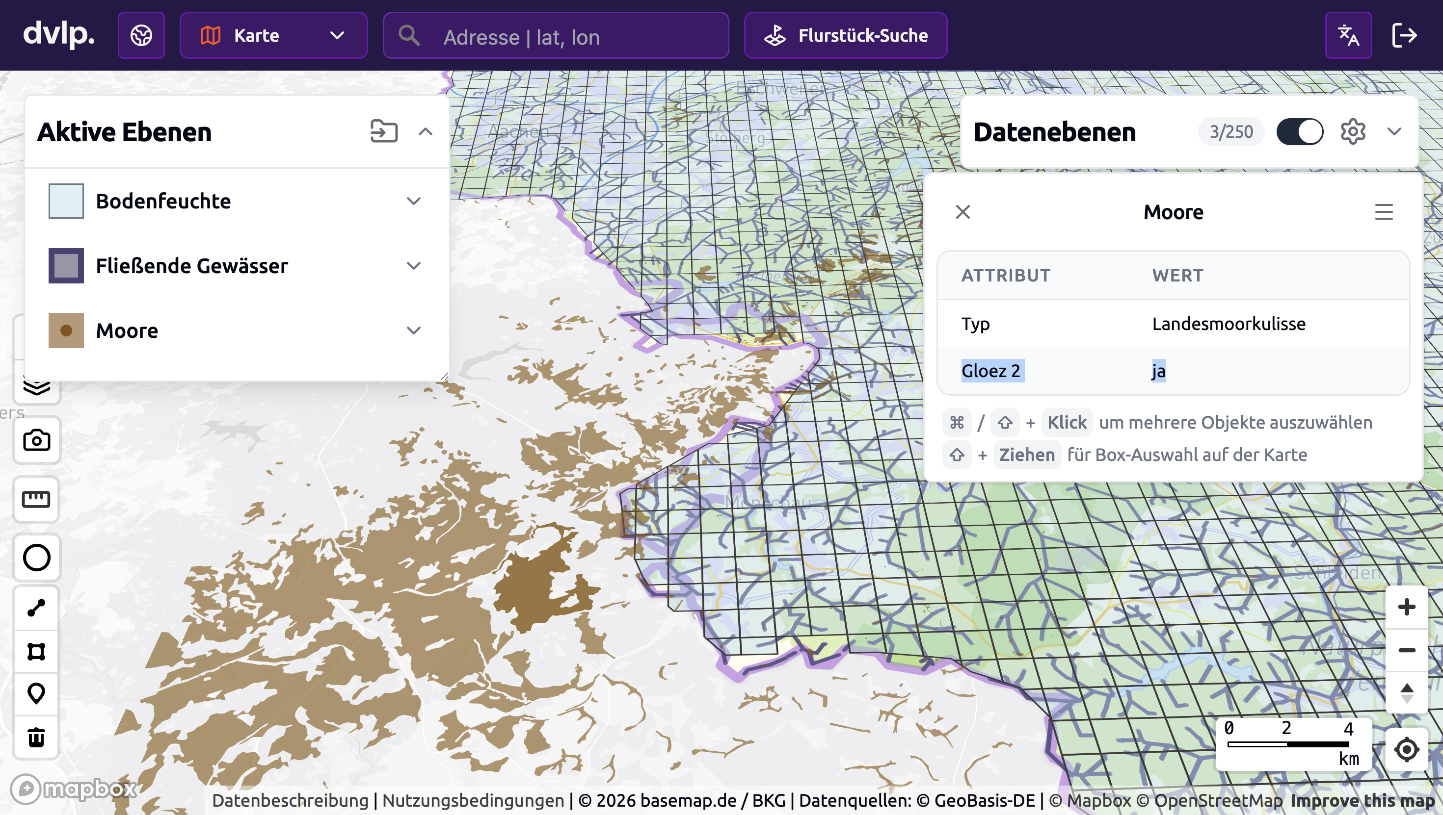
The GLÖZ II reference layers from all German federal states are integrated into the dvlp.energy Web GIS. This makes it possible to identify at an early stage whether a site lies within a designated layer and where more detailed assessment may be required.
Image caption: GLÖZ II (GAEC 2) reference layer in the dvlp.energy Web GIS. Brown areas form part of the federal-state peatland reference layer and may need to be considered when screening peatland PV projects.
What the GLÖZ II reference layer shows – and what it does not
The integrated reference layer helps teams to:
- identify affected sites at an early stage;
- recognise potential implications for subsequent project planning;
- compare different sites consistently; and
- initiate additional technical or legal assessments where needed.
A site’s location inside or outside a GLÖZ II reference layer is not, however, a definitive determination of whether a solar project is eligible for support under the EEG.
Depending on the project, the actual soil conditions, the feasibility and design of rewetting, nature conservation requirements, ownership, permitting issues and the current requirements of the German Federal Network Agency must also be assessed.
The data therefore serves primarily as a screening and decision-support tool at an early stage of project development. It is not a substitute for a project-specific technical or legal assessment.
Conclusion
The new Fraunhofer guidance document highlights the substantial technical potential of peatland PV. A robust site assessment begins with the correct interpretation of the available data.
GLÖZ II reference layers provide an important spatial basis: they help identify relevant sites early, make uncertainty visible and focus further assessment on the sites that matter.
Further information
- Fraunhofer ISE: Guidance document on peatland PV
- Section 37 of the German Renewable Energy Sources Act (EEG)
- Section 11 of the German CAP Conditionality Ordinance (GAPKondV)
- German Federal Network Agency: Special solar installations on grassland and peat soils
- German Federal Agency for Nature Conservation: Solar installations on peat soils
Note: This article provides an overview of the current framework and does not replace a project-specific legal or technical assessment.
More blog posts

%20(1).png)

Request a demo now

