Where could the expansion of renewables be slowed down in the future?
This question has been raised since the draft bill by the Federal Ministry for Economic Affairs and Energy (BMWE) was made public for a “law amending energy industry law to synchronize plant expansion with grid expansion and to improve the grid connection process.”
Where could the expansion of renewables be slowed down in the future?
The Draft Bill and Its Potential Consequences
This question has arisen since the Federal Ministry for Economic Affairs and Energy (BMWE) released its draft bill for a “Law Amending Energy Industry Legislation to Synchronize Plant Expansion with Grid Expansion and to Improve the Grid Connection Procedure.” (Link)
The draft proposes introducing a new Section 14(1d) into the Energy Industry Act (EnWG), under which distribution system operators would be able to designate so-called capacity-limited substations and line sections if the “technically feasible electricity feed-in from directly or indirectly connected facilities was adjusted by a total of more than 3 percent in the preceding calendar year.” Such adjustments are also referred to as redispatch. Plant operators are currently compensated for the lost revenue from the curtailed energy volume.
However, in connection with the also proposed amendment to Section 8(4) of the Renewable Energy Act (EEG), grid operators will then only be obligated to connect renewable energy plants if the operators waive their right to financial compensation.
Since project developers and plant operators find it difficult to estimate how often the generation from newly planned solar or wind farms will need to be curtailed by distribution system operators, the financial viability and thus the feasibility of these projects in these capacity-constrained regions is called into question.
Availability of Data on Redispatch Measures
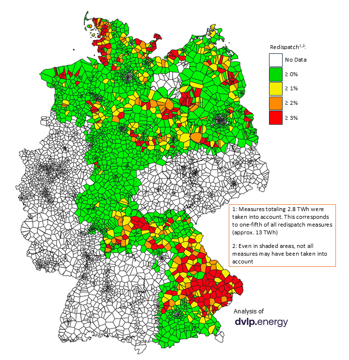
To better assess the impact of this potential new regulation, the team at dvlp.energy analyzed all plant-specific redispatch measures that have been published. This allowed them to identify the grid elements where more than three percent of the generated electricity was curtailed last year. The analysis covers measures from March 2025 to February 2026, with a total curtailed energy volume of 2.8 TWh. This represents approximately one-fifth of the total redispatch volume of about 13 TWh (excluding interventions resulting from exchange trading).
The discrepancy between redispatch measures published on a specific-facility basis and the total volume arises because, on the one hand, not all grid operators publish redispatch measures and, on the other hand, not all published measures can be assigned to specific facilities. Nevertheless, this approach allows for the most granular possible representation of the grid elements affected by the redispatch reserve and their catchment areas.
Regions with Limited Capacity
Even when considering only one-fifth of all redispatch measures, the catchment areas of grid elements affected by more than 3% redispatch already cover seven percent of the country’s total area. The northwest of Lower Saxony, Schleswig-Holstein, and Brandenburg; the northeast of Saxony-Anhalt; and the north and east of Bavaria would be particularly affected. However, there are significant regional differences.
In general, the north is characterized primarily by high electricity feed-in from wind farms. For example, at the Werdum and Altfunnixsiel substations in the municipalities of Esens and Wittmund (Lower Saxony), 28 percent and 17 percent of the technically possible feed-in is already being curtailed. In the districts of Dithmarschen and Nordfriesland (Schleswig-Holstein), more than three percent is curtailed at nearly all substations. In Brandenburg, the district of Prignitz stands out in particular, where 29 percent of the technically feasible feed-in is curtailed at the Groß Werzin substation alone.
In Bavaria, on the other hand, the feed-in of solar power is the capacity-limiting factor. In the majority of municipalities in the Landshut and Donau-Wald planning regions, well over five percent of the technically feasible renewable electricity feed-in is already being curtailed—almost all of which comes from photovoltaic systems, as there are hardly any wind farms. In the more northern planning regions of Regensburg, Oberpfalz-Nord, and Main-Rhön, the catchment areas of grid elements with more than 3 percent curtailment already account for approximately 50 percent of the total area—here, solar and wind power are often in balance.
The Impact and More Effective Alternatives
In all these regions, the proposed legislation could make it impossible to finance new renewable power generation projects due to a lack of compensation for lost revenue from curtailed energy volumes. If one considers the catchment areas of grid elements with redispatch rates already exceeding 2 percent, the total affected area in Germany rises from seven to eleven percent—and this is based on considering only one-fifth of all redispatch measures. The proposed “redispatch reservation” would thus lead to a significant regional slowdown in the expansion of renewable energy.
Furthermore, the draft bill fails to take into account that a new wind turbine at a grid node with solar-dominated redispatch does not necessarily lead to an increase in local redispatch. It also ignores the fact that the selection of sites for wind farms is generally determined by planning regions through the designation of priority areas. Project developers are therefore only able to avoid capacity-constrained areas to a limited extent.
The alternative would be to increase grid flexibility through grid expansion, battery storage, and making consumption more flexible, in order to utilize excess electricity from non-dispatchable wind and solar farms. The real key to reconciling renewable energy expansion and “grid” expansion without slowing down the former lies in market-based or contractual incentives and safeguards for this potential. This key already exists, as numerous privately financed battery storage projects have been developed but are not being granted grid connection. Effective measures to turn this key and connect the battery storage systems to the grid are not (yet) included in the current draft legislation.
The Methodology
Identifying capacity-constrained substations and transmission line sections independently is challenging for three main reasons:
- The geographic locations of power generators’ grid connections are not publicly available, so it is not possible to say exactly which substation or line section they are directly or indirectly connected to
- Only a few distribution system operators publish redispatch data at the facility level. All others publish redispatch measures only in general terms, without specific facility references, or not at all, making it impossible to determine their geographic location
- The amounts of energy generated by renewable power plants are not publicly available, so the “technically feasible electricity feed-in” and the feed-in curtailed due to redispatch must be determined by other means
The team at dvlp.energy has therefore calculated the technically feasible and the regulated power feed-in from the power generators located within the catchment areas of substations using
- master data from the Market Master Data Register (location, capacity, technology)
- weather data from the German Weather Service (global radiation, wind speeds)
- Published redispatch measures related to specific plants (degree and duration of curtailment)
This approach allows for the most granular representation possible of the substations and their service areas that would be affected by the redispatch reservation.
This article was updated on March 13. Specifically, the following changes were made:
- the description of the results and the graph regarding the catchment areas of substations (previously: administrative municipalities)
- the classification of the volume of the analyzed redispatch measures in comparison to the total volume of all redispatch measures in Germany